
Originally announced at Google I/O 2019, the ‘Live View’ feature in Google Maps started rolling out globally last August. It is now available as an option to accurately pinpoint your location in the app. Believed to have been first reported on by 9to5Google, users can now use the ‘Calibrate with Live View’ option to improve the accuracy of their location in Google Maps.
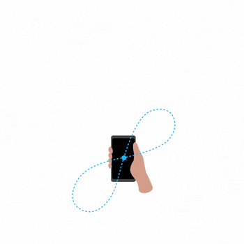
Users, until now, could only calibrate the orientation of the geo-magnetic sensor (electronic compass) in their smartphones by moving the device in a ‘figure 8’. That will remain the case for the sensor itself. However, Google Maps will now be able to improve its accuracy with the new feature. The option can reportedly be accessed by tapping on the blue dot seen in the GIF below.
Users can apparently tap on the blue dot to bring up the menu options seen below. As you can see, the final option on the list will be ‘Calibrate with Live View’. Choosing that option will open the camera UI used by Live View. According to the report, it will only take a few seconds of panning for the app to correctly access your location. Once that happens, the blue beam will be replaced by a solid arrow.

‘Calibrate with Live View’ has started rolling out to the latest stable and beta versions of Google Maps on several ARCore-compatible Android devices. It is, however, not available on iOS just yet. However, you’d expect Google to eventually roll it out on iPhones as well. So, is the new feature available on your device yet? Let us know in the comments below.