


GLONASS is an acronym, which stands for Globalnaya Navigazionnaya Sputnikovaya Sistema, or Global Navigation Satellite System. GLONASS is Russia’s version of GPS (Global Positioning System).
Who built GLONASS?
Soviet Union started the development of GLONASS in 1976. GLONASS is the most expensive program of the Russian Federal Space Agency, consuming a third of its budget in 2010.
Versions-
The various versions of GLONASS are
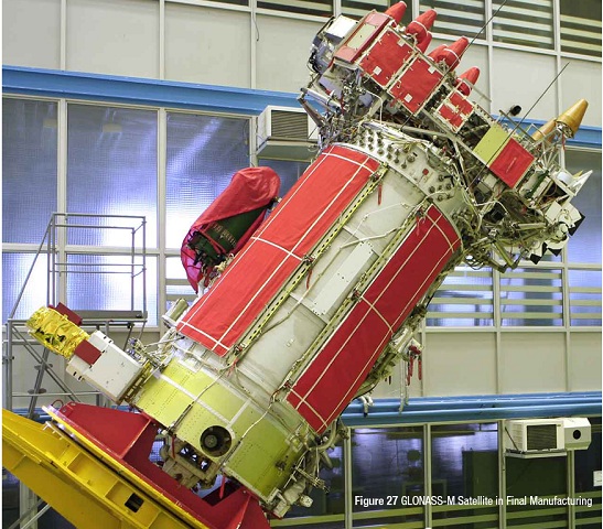
- GLONASS – launched in 1982, the satellites launched were intended to work for weather positioning, velocity measuring and timing anywhere in the world or near-Earth space by the military and official organisations.
- GLONASS-M – launched in 2003 add second civil code. It is important for GIS mapping receivers.
- GLONASS-k – started in 2011 again has 3 more types namely k1, k2 and km for research. Adds third civil frequency.
- GLONASS-K2 – will be launched after 2015 (currently in design phase)
- GLONASS-KM – will be launched after 2025 (currently in research phase)
What is A-GLONASS?
A-GLONASS, Assisted GLONASS is very similar to GLONASS but A-GLONASS brings more features for smartphones. It brings features such as turn by turn navigation, real time traffic data and more. It uses the cell towers near your location to lock your location quickly with the help from your data connection. A-GLONASS also enhances the performance in chip-sets that come with GLONASS support.
How much did GLONASS cost?
Up to 2011 the Russian government spent about 5 billion dollars on GLONASS project, and further invested 320 billion rubles ($10 billion) for the period of 2012 to 2020. GLONASS happens to be the most expensive project ever by Russian Federal space Agency.
How is GLONASS different from GPS?
GPS developed by USA has a network of 31 satellites covering this planet and has been widely used in commercial devices like mobile phones, navigators etc.
GLONASS is developed by Russia originally started by Soviet Union in 1976. This has a network of 24 satellites covering the earth.
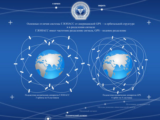
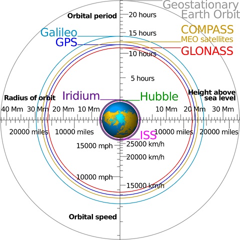
The image shows the orbit and constellation of GLONASS (left) and GPS (right).
Here is a table of specs comparing GPS vs GLONASS
| Specification | GLONASS | GPS |
|---|---|---|
| Owner | Russian Federation | United States |
| Coding | FDMA | CDMA |
| Number of satellites | At-least 24 | 31 |
| Orbital Height | 21150 Km | 19130 km |
| Accuracy | Position: 5–10 m | Position: 3.5-7.8 m |
| Orbital plane inclination | 64.8 degree | 55 degree |
| Orbital period | 11 hours and 16 minutes | 11 hours and 58 minutes |
| Frequency | Around 1.602 GHz (SP) Around 1.246 GHz (SP) | 1.57542 GHz (L1 signal) 1.2276 GHz (L2 signal) |
| Status | Operational | Operational |
Advantage of GLONASS over GPS (GLONASS Vs GPS)
There is no clear advantage other than accuracy over GPS. When used alone GLONASS doesn’t have that strong coverage as GPS has, but when both used together certainly increases accuracy with coverage. And it is more useful in northern latitudes as Russia started GLONASS originally for Russia.
The accuracy is an advantage of GLONASS with up-to 2 meter of accuracy. GPS + GLONASS allows your device to be pin pointed by a group of 55 satellites all across the globe. So when you are in a place where GPS signals are stuck like between huge buildings or subways, you will be tracked by GLONASS satellites accurately.
Commercial Use of GLONASS
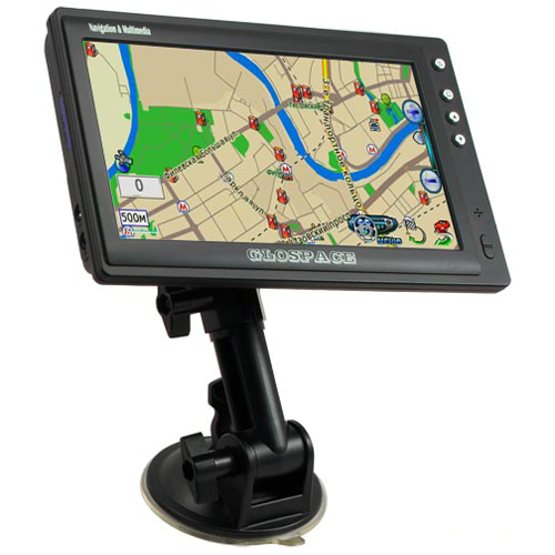
GLONASS was first commercially used in car navigator as Glospace SGK-70 but was bulky and expensive. Russian government is trying hard to promote GLONASS commercially.
iPhone 4S was the first apple product to use both GPS and GLONASS for pinpointing location on maps.
All the high end devices that supports GPS facilities, especially navigators include GLONASS receivers on their chip to use location based services.
What is offered for smartphones?
Today any mobile phone whether it is a high end or a low budget smartphone is equipped with A-GPS (assisted Global Positional System) which uses network capabilities to find your location.
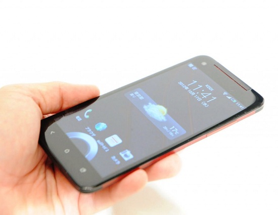
Now with GLONASS being offered for public services, more and more smartphones are being launched with GPS+GLONASS technology to use dual core location based service to find location. Initially only Flagship or high end smartphones boasts these features but as time will progress, we will see both these technologies being equipped on low and mid-range smartphones. More and more companies and chip manufacturers seem to be interested in GLONASS technology, so more and more smartphones are expected to be launched with this technology.
List of Smartphones supporting GLONASS
| Smartphone Manufacturer | Mobile Phone Model |
|---|---|
| Acer | Acer Liquid S2 |
| Alcatel | Alcatel OT-995 |
| Apple | iPhone 4S |
| Apple | iPhone 5 |
| Apple | iPhone 5C |
| Apple | iPhone 5S |
| Asus | PadFone 2 |
| Asus | PadFone Infinity |
| Asus | ASUS MeMO Pad FHD 10 ME302C |
| Asus | ASUS MeMO Pad 10 ME102A |
| Asus | ASUS MeMO Pad 7 ME176C |
| Asus | ASUS Fonepad 7 ME372CG |
| Asus | ASUS Fonepad 7 ME175CG |
| BlackBerry | BlackBerry Z10 |
| BlackBerry | BlackBerry Q10 |
| HTC | HTC Butterfly |
| HTC | HTC Butterfly S |
| HTC | HTC Desire 600 |
| HTC | HTC Droid DNA |
| HTC | HTC Evo 3D |
| HTC | HTC First |
| HTC | HTC One |
| HTC | HTC One Mini |
| HTC | HTC One Mini 2 |
| HTC | HTC One S |
| HTC | HTC One SV |
| HTC | HTC One X+ |
| HTC | HTC One V |
| HTC | HTC Windows Phone 8S |
| HTC | HTC Windows Phone 8X |
| Huawei | Huawei Ascend D1 Quad XL |
| Huawei | Huawei Ascend G600 |
| Huawei | Huawei Ascend G615 |
| Huawei | Huawei Ascend Mate |
| Huawei | Huawei Ascend P2 |
| Huawei | Huawei Ascend P6 |
| Huawei | Huawei Honor (U8860) |
| Huawei | Huawei Honor 2 |
| LG | LG Nexus 4 |
| LG | LG Nexus 5 |
| LG | LG Optimus G |
| LG | LG G2 |
| LG | LG G2 mini |
| LG | LG Optimus G Pro |
| LG | LG Optimus Sol |
| LG | LG Venice |
| LG | LG Optimus L9 |
| LG | LG Optimus L9II |
| LG | LG G3 |
| LG | LG Volt |
| Meizu | Meizu MX2 |
| Motorola | Motorola Atrix HD |
| Motorola | Motorola Moto E |
| Motorola | Motorola RAZR |
| Motorola | Motorola MOTO G |
| Motorola | Motorola MOTO X |
| Motorola | Motorola RAZR HD |
| Motorola | Motorola RAZR M |
| Motorola | Motorola RAZR MAXX |
| Motorola | Motorola DROID 4 |
| Motorola | Motorola DROID RAZR |
| Motorola | Motorola DROID RAZR HD |
| Motorola | Motorola DROID RAZR M |
| Motorola | Motorola DROID RAZR MAXX |
| Motorola | Motorola DROID RAZR MAXX HD |
| Nokia | Nokia Lumia 520 |
| Nokia | Nokia Lumia 525 |
| Nokia | Nokia Lumia 620 |
| Nokia | Nokia Lumia 625 |
| Nokia | Nokia Lumia 710 |
| Nokia | Nokia Lumia 720 |
| Nokia | Nokia Lumia 800 |
| Nokia | Nokia Lumia 820 |
| Nokia | Nokia Lumia 822 |
| Nokia | Nokia Lumia 900 |
| Nokia | Nokia Lumia 920 |
| Nokia | Nokia Lumia 925 |
| Nokia | Nokia Lumia 928 |
| Nokia | Nokia Lumia 1020 |
| Nokia | Nokia Lumia 1520 |
| OnePlus | One |
| Samsung | Samsung Galaxy S Duos 2 |
| Samsung | Samsung Galaxy Ace 2 |
| Samsung | Samsung Galaxy Ace 3 |
| Samsung | Samsung G350 Galaxy Core Plus |
| Samsung | Samsung Ativ S |
| Samsung | Samsung Galaxy Chat |
| Samsung | Samsung Galaxy Exhilarate |
| Samsung | Samsung Galaxy Express |
| Samsung | Samsung G3815 Galaxy Express 2 |
| Samsung | Samsung Galaxy Grand |
| Samsung | Samsung Galaxy Grand 2 |
| Samsung | Samsung Galaxy Mega |
| Samsung | Samsung Galaxy Music |
| Samsung | Samsung Galaxy Note |
| Samsung | Samsung Galaxy Note II |
| Samsung | Samsung Galaxy Note III |
| Samsung | Samsung Galaxy Pocket |
| Samsung | Samsung Galaxy Pocket Neo |
| Samsung | Samsung Galaxy Fame |
| Samsung | Samsung Galaxy S II Plus |
| Samsung | Samsung S7582 Galaxy S Duos 2 |
| Samsung | Samsung Galaxy S III |
| Samsung | Samsung Galaxy S III Mini |
| Samsung | Samsung Galaxy S IV |
| Samsung | Samsung Galaxy S IV Active |
| Samsung | Samsung Galaxy S IV duos++ |
| Samsung | Samsung Galaxy S V |
| Samsung | Samsung Galaxy S Relay 4G |
| Samsung | Samsung Galaxy Xcover 2 |
| Samsung | Samsung Galaxy Win GT-I8552 |
| Samsung | Samsung Omnia W |
| Samsung | Samsung S8600 Wave III |
| Samsung | Samsung Focus |
| Samsung | Samsung Galaxy Trend 7392 |
| Samsung | Samsung S7580 Galaxy Trend Plus |
| Samsung | Samsung z |
| Sony Ericsson | Sony Ericsson Xperia active |
| Sony Ericsson | Sony Ericsson Xperia arc |
| Sony Ericsson | Sony Ericsson Xperia arc S |
| Sony Ericsson | Sony Ericsson Xperia neo |
| Sony Ericsson | Sony Ericsson Xperia neo V |
| Sony Ericsson | Sony Ericsson Xperia pro |
| Sony Ericsson | Sony Ericsson Xperia ray |
| Sony Ericsson | Sony Ericsson Xperia acro hd |
| Starmobile | Starmobile Navi |
| Sony | Sony Xperia acro HD |
| Sony | Sony Xperia acro S |
| Sony | Sony Xperia AX |
| Sony | Sony Xperia ion |
| Sony | Sony Xperia neo L |
| Sony | Sony Xperia S |
| Sony | Sony Xperia SL |
| Sony | Sony Xperia SP |
| Sony | Sony Xperia SX |
| Sony | Sony Xperia T |
| Sony | Sony Xperia TL |
| Sony | Sony Xperia TX |
| Sony | Sony Xperia V |
| Sony | Sony Xperia VL |
| Sony | Sony Xperia Z |
| Sony | Sony Xperia Z Ultra |
| Sony | Sony Xperia ZL |
| Sony | Sony Xperia ZR |
| Sony | Sony Xperia Z1 |
| Sony | Sony Xperia Z2 |
| Xiaomi | Xiaomi Phone 2 |
| Xiaomi | Xiaomi Phone 2A |
| Xiaomi | Xiaomi Phone 2S |
| Xiaomi | Xiaomi Phone 3 |
| ZTE | MTS 945 |
How Google Maps makes use of GLONASS and GPS?
Google Maps and the other mapping apps like Nokia’s HERE Maps and Apple Maps use the data connection to connect to the satellites of GLONASS and GPS. The modern day smartphones come with A-GPS and A-GLONASS support, which brings features such as turn by turn navigation, location tracking and real time location info.
What’s next after GLONASS and GPS?
- European Union is currently working on a system called GALILEO which provides highly accurate global positioning service under civilian control. Galileo system consists of 30 satellites (27 operational + 3 active spares), positioned in three circular Medium Earth Orbit planes at 23 222 km altitude above the Earth, and at an inclination of the orbital planes of 56 degrees to the equator.
- China is developing its own constellation of 35 satellites called BeiDou Navigation Satellite System and is under construction since January 2015. It will offer more capabilities than current GPS. It is currently operational in China and Asia pacific region with 11 satellites in use, will be globally available by 2020.
- IRNSS or Indian Regional Navigation Satellite System is autonomous satellite system being developed by ISRO (Indian Space Research Organisation) and will offer public service and restricted service (authorized users like military). This system would consist constellation of 7 satellites out of which 4 are already placed in the orbit. The project is expected to be operational by 2016.
If you have something to say, feel free to leave a comment below the article.
Image Courtesy: Wikipedia


 Kanika Gogia

 Abubakar Mohammed

 Sagnik Das Gupta

 Arjun Sha
 Kanika Gogia
 Anshuman Jain
 Abubakar Mohammed

my lumia 820 has an ofline map which is live and most accurate and works without internet connection, but my new redmi note 4 cant work ofline, it requited internet, with internet it cant give perfect location. whats the reason ?
For android devices, you can download Here WeGo, It has offline maps capability, as long as your phone has satellite GPS functionality it will be able to track your location when out of range of cell towers. Some phones, mostly older ones, only use cell towers for GPS, for phones that only use cell towers for GPS your phone must be able to reach at least 3 towers to find your location.
Wow, yes I use GPS but I also have the lost talent of knowing how to read a paper map.
`reboot`
I believe all the 3 (GPS, Glonass or Beidou) will be useful based on the demand and geography!
Most of us are concerned about our smartphones’ accuracy & abilities for location & navigation. People should know that in addition to GPS-type satellite information (that requires only a decent radio “view” of the sky), our phones build in additional triangulation from known wifi locations, cell towers and its onboard gyros & magnetometers.
GPS only needs the ability to receive a signal, and so doesn’t use much battery. That’s why it can be in a titbit-type device with tiny batteries lasting days. Other location information—and especially, updated local maps—require your phone to ask a service provider for the relevant data. It’s too much, and changes enough with new landmarks, road changes etc. to store locally
with so many devices up in space glonass / gps etc ? but nobody was able to track down the missing airliner ?
Of course not. The aircraft without doubt had the required GPS and perhaps also GLONAS and some of the others installed. But right from the early days it was reported that somebody had switched off power to sucsh navigation systems. Therefore, such systems were unavailable to track the airliner. It now looks like it will never be found. SAD INDEED!
How do the positioning systems provide turn-by-turn navigation. I always thought the positioning systems provide a device’s position in longitude and latitude to a maps software which then calculates turn-by-turn navigation. Is anyone able to explain?
Turn by Turn navigation is provided not only by the use of GPS or Glonass. Its a combination of other sensors. For example a magnetometer provides north south east west heading. Accelerometer and Gyroscope provides directional and rotational acceleration. A combination of these sensors and a lot of filtering and algorithms are used to calculate the position as accurately as possible.
It sounds like hype. It looks like an identical system to GPS, except that Russia does not have to rely on the USA for it, and maybe you can get a bit better coverage and accuracy by using both.
You are correct that GPS only reports position and the map software does the rest. Other sensors are not necessary to compute turn by turn directions. Frequent GPS sampling will give heading (course actually, but it’s hopefully the same for a car), speed and angular rate of change in course for turns. The software on the device or on the server that the device is communicating via cell towers figures out the rest.
Any halfway-smart system designer will get a host of inputs with different types of errors so they can correct against each other.
Gyroscopes and magnetometers all provide much quicker indications of changes in direction and short-term speed than relying on the satellites’ positioning info, which are fine for higher-speed, straight-line use—like a car on a highway—but their uncertainty area can’t detect that you walked around the corner until you’ve gone a ways in that direction.
Well copied from Wikipedia.. Its like making notes from a book for exams..Comparison image content of GLONASS and GPS is not even visible.
At least he sumerizd this technologies properly and we can get all the information in one place …
Thank you for this article.
Very helpful article. One question though: Can devices equipped with GPS/GLONASS receivers provide navigation *without* a cell phone or WiFi connection? Thank-you.
Sure, just make sure your maps are downloaded for offline usage
So, when SpaceX has launched all its 700 micro-satelites providing blanket low earth orbit wifi coverage of the planet, will these be any use for navigation (from a positioning POV)?
Not unless they know where they are and have atomic clocks on board. My understanding is that the micro-satellites you are talking about will not be in geosynchronous orbit, so they will have to know where they are and the most logical way they might know that is from the GPS satellites.
The picture shows GLONASS to be at a lower altitude than GPS, yet the table shows Orbital Height of 21150 Km for GLONASS, and 19130 km for GPS. Where is the error? Or am I reading something incorrectly?
I noted this as well. I need clarification on that.
Unless the picture changed the picture shows GLONASS as clearly higher than GPS. It’s not vague or close.
Ahh, Gordon Freeman, in the flesh – or, rather, in the hazard suit.
Thank you very much for great information.
What if all these countries worked together?? Wouldn’t the resulting system be incredible… just sayin’
Mr Mark… What if they all worked together ? They do.
Modern receivers can receive GLONASS/GPS/Galileo so they do work together.
The more satellites you have , the greater the accuracy.
And a note to the author. Please use articles. It’s not “Soviet union did X. European Union did Y” they are THE soviet union and THE European union. It’s a small thing, but it makes your article read so much better if you use them.
I just hope that all these little gadgets never fell down into our heads!
Thanks Buddy!
Thanks from Athens Greece.
great article
Thanks alot for this info
thanks dear
Thank you very much for providing this information, your working so appreciable on this article. Thanks again bro.
Thanks
Thank you !
If all countries worked together to share all navigational and construction positioning satellites, what would be the optimum number?
That would be dependent upon how accurate you want the positioning to be. Current systems are accurate to within 2M generally, and 0.5M with a higher satellite count. To get more accurate than that, the number of satellites would have to become exponentially greater. This is almost always the case, no matter what type of system you are using. For instance, to double the range of a radio signal, you need 4 times the power. With satellites, you’re also dealing with atmospheric anomalies, extra solar radiation, and other factors, so it isn’t as cut and dried as you might think.
Ahh, Gordon Freeman, in the flesh – or, rather, in the hazard suit.