While India is certainly late to the development of an indigenous satellite navigation system, it’s still a huge advancement as only a handful of countries have made to the elite club so far. In case you are unaware, India has announced its autonomous satellite navigation system for public use after 7 years of rigorous development, testing, and evaluation. Starting this year, you can have commercial smartphones, fitness bands, and vehicles with the NavIC positioning system. In a way, it will replace GPS, and that is going to be fascinating to watch, at least in India. So, if you want to learn, what is NavIC and how it is better than GPS then go through our explainer point by point.
India’s NavIC System Explained
What is NavIC: A Brief Introduction
Before we wade into technicality, let’s first know what NavIC stands for. NavIC is a short form for Navigation with Indian Constellation and is a popular moniker among the general public for India’s GPS alternative. Actually, the name of the project is IRNSS which elaborates to Indian Regional Navigation Satellite System. By now, you might have got a faint idea about the objective of NavIC but let me explain thoroughly.


NavIC is a regional navigation satellite system built by India for India. It’s designed by ISRO for accurate real-time positioning, timing services, and messaging. Basically, it’s an alternative to GPS (Global Positioning System) which is developed and run by the US. The prime difference between NavIC and GPS is that the former is built primarily for India including some neighboring countries whereas GPS (US) offers coverage of all regions around the globe.
The reason India built its own navigation system is to limit its over-reliance on US technologies. Other countries have already deployed their own navigation satellite systems and now India has made NavIC operational after 7 years of rigorous testing and development. To give you a few examples, Russia operates GLONASS which is a global navigation system; China has BeiDou which is a regional navigation system just like India; Europe has Gallileo which is a global navigation system and so on. While currently, India is focussing on its region and adjoining neighbors, ISRO plans to increase the coverage area around the globe in the coming years.
How NavIC Works?
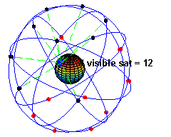
I am going to explain the NavIC satellite navigation system in lucid language so don’t worry about the technicality and read on. First of all, NavIC has currently a total of 7 satellites that are stationed in the high orbit of the Earth which is approximately at an altitude of 35k km from Earth’s surface. And all of the satellites are in direct line of sight with India. ISRO maintains the perfect line of sight by rotating the satellites at a fixed velocity. The satellites complete one complete rotation in 23 hours, 56 minutes, and 4 seconds which is the exact orbital period of the Earth so it matches perfectly.


Among the 7 satellites, 3 revolve in the geostationary orbit and are constantly in direct line of sight with India’s ground station. Whereas, 4 of the satellites are in the geosynchronous orbit inclined at 29 degrees to the Equator. Incidentally, the movement of 4 satellites at the given inclination resemble the figure of 8– which, by the way, is called Analemma in Astronomy.


Coming back to NavIC satellites, each one has three Rubidium Atomic clocks which are essentially the device to calculate the distance, time, and your precise position on Earth using radio frequencies. The key takeaway from the working mechanism is that NavIC satellites always maintain the direct line of sight with India — unlike GPS — which results in highly precise geolocation, faster latching, and more penetration in dense areas.
NavIC vs GPS: The Future of India’s Satellite Navigation System
Coverage
First and foremost, let’s talk about coverage as it’s one of the most important aspects of a satellite navigation system. As I already said, NavIC is a regional satellite navigation system that covers India and some neighboring countries. To be specific, NavIC covers the whole of India and 1500kms of the area from its borders. As a result, the coverage of NavIC extends to Bangladesh, Pakistan, Sri Lanka, and some northern parts of China too.


Whereas, GPS covers the whole world so there is no competition here in terms of coverage. However, we have to remember again that NavIC has been developed for India and will extend its coverage in the coming years. ISRO has already committed to launch 4 more satellites to improve coverage and position accuracy.
Satellites
As I mentioned above, currently, NavIC has a total of 7 satellites in Earth’s orbit whereas GPS has a total of 31 operational satellites rotating around the Earth. While GPS needs only 24 satellites to cover all the regions, recently the US increased the number of satellites for accurate location mapping. Also, it must be noted that India has kept two additional satellites on the ground as stand-by.


Apart from that, NavIC uses L5 frequency to locate devices like smartphones and commercial vehicles. This service for general users has been named as Standard Positioning Service(SPS). On the other hand, NavIC uses the S-band frequency for military use which is encrypted and not open for public use. It has been named Restricted Service. I have talked about the implications of different frequencies in the “Accuracy” section so go through that for a better idea. Talking about GPS, it uses L1 and L5 frequencies for both general and military use.


So in terms of the number of satellites, GPS obviously has an upper hand as it covers the whole world. However, if we look from the frequency and security point of view then NavIC is following the standard protocols used by major space agencies and is on par with GPS.
Accuracy
Now we come to the most essential part of this discussion between NavIC vs GPS: Position Accuracy. Without any caveat, let me tell you in the very beginning, the best part about NavIC is accuracy and it’s better than GPS. As I extensively explained in the working mechanism of NavIC above, the reason for its pinpoint accuracy is the direct line of sight between the satellite and India’s region — ALL the time. And that is what makes it the best satellite navigation system for India, even better than GPS or any other system. You will always be visible to one of the 7 satellites rotating in geostationary orbit, directly in sync with India’s co-ordinates.


In contrast with US’ GPS, the 31 satellites are rotating around the Earth at various degrees of inclination so you keep on latching from one satellite to another. It takes significant time to acquire the position of the object. On top of that, GPS’s satellites take 11hr to complete Earth’s rotation in comparison to NavIC’s 24 hours (approx). As a result, the GPS’s satellites move at an astounding speed so again you keep on latching from one satellite to another which takes more time and the accuracy takes a hit. It especially becomes a major problem when you are in dense areas.

Now we come to location accuracy in the mountains. For all we know, the constellation of NavIC satellites operates at a higher orbit — approx 35k km above the Earth’s surface. On the other hand, GPS satellites operate in medium Earth orbit which is at approximately 20k km of altitude. Since NavIC satellites are much above the Earth’s surface, signals can’t be blocked by mountains. On the other hand, GPS satellites are operating at medium orbit so there are chances of signal blocking by mountains especially on the horizon. So in a way, NavIC has been designed to work across the length and breadth of India without any obstruction — be it the remote Himalayan mountains or terrestrial surface.

That was all about the pros and cons of NavIC and GPS accuracy in India. Theoretically, NavIC has a position accuracy of 5-20 meters for general users and 0.5 meters for military use which is amazing. And GPS also has a similar position accuracy of less than 20 meters but can get better with Cellular triangulation. However, the US has not disclosed its GPS accuracy for Military use.
To sum up, NavIC has a direct line of sight with India all the time so the position accuracy remains better than GPS, especially in mountain regions. Whereas GPS has ample satellites, but stationed at medium-orbit and cruising at a faster velocity which results in longer acquisition time and relatively inaccurate positioning. Not to mention, in a geographically diverse India, GPS is more prone to position inaccuracy than NavIC.
Are There Any Issues with NavIC?
While on the user side of the things, we do not have any experiences to share as commercial products are yet to hit the market. However, in 2016 and 2017, there were reports of Atomic clock failure in the NavIC satellites. A similar thing happened with the European Union’s Galileo satellites as well. To prevent the issue, ISRO is using only one Atomic clock on each satellite and keeping the other two clocks as backups. In addition, the Atomic clocks on the two stand-by satellites on the ground have gone through further improvements.
NavIC Availability in India
Back in October 2019, ISRO signed a pact with Qualcomm to bring NavIC-compatible smartphones to India. Soon, Qualcomm announced that Snapdragon 720G, 662, 865, 765, and 460 processors will come with NavIC support. Fast forward to 2022, and almost all of the new chipsets, including the latest Snapdragon 8+ Gen 1 and Dimensity 9000, have built-in support for NavIC.

Apart from smartphones, NavIC-based trackers have been made compulsory on commercial vehicles in India, so all future vehicles are going to sport the indigenous NavIC system. As for the NavIC availability on smartphones, the Indian government recently held a private meeting with officials from Apple, Samsung, Xiaomi, etc. to make NavIC mandatory on smartphones, according to a Reuters report. The govt. is said to be pushing manufacturers to enable NavIC on all new smartphones starting from January 1, 2023.
However, industry officials, primarily from Apple and Samsung, are pushing back against the implementation of NavIC on their devices. Handset makers are of the opinion that it will increase changes in the hardware, will require more research, and add to their overall costs. The report also suggests that industry officials are seeking time till 2025 to implement NavIC on their smartphones. In response to the report, the Indian govt. tweeted saying that the timeline has not been fixed yet and the issue is under discussion.
Having said that, it seems like, of all the companies, Apple will be the last to support NavIC on iPhones. Qualcomm and MediaTek have done a great job and have already implemented NavIC in their SoC design. Now, handset makers just need to enable it through a software update. We have seen smartphones from Xiaomi and Realme supporting NavIC, but strangely, Samsung phones don’t have NavIC support at all even when the chipsets come with the hardware capability. It seems like both Apple and Samsung will try to buy more time from the Indian government to implement NavIC on their smartphones.
However, if you looking to buy a smartphone with NavIC support in India right now, check our linked article for an updated list of devices that support this technology in 2022.
Frequently Asked Questions
Can We Get NavIC Support by a Software Update?
The answer is no. You need to have the dedicated NavIC tracking unit incorporated into the smartphone SoC. Only after that, the smartphone manufacturer can enable the support through a software update, if not enabled already.
Does Google Maps support NavIC?
Yes. On the software side of things, any navigation app including Google Maps doesn’t have to make any changes to support NavIC-based navigation. It will work out of the box.
How to Check NavIC Support on Your Smartphone?
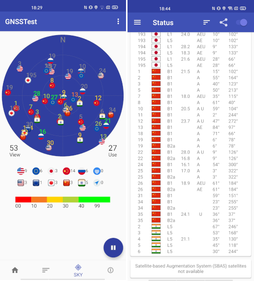
You can install GPSTest (Free) and GNSSTest (Free) on your Android smartphone to check NavIC compatibility. If the apps detect Indian satellites then your smartphone does support NavIC. For better satellite detection, start the test outdoors.
NavIC vs GPS: The New-Age Satellite Navigation System
So that was all about NavIC and how it’s different than the already-dominant navigation system, GPS. The story of NavIC is not about its technical marvel but of India’s quest towards self-dependency. And ISRO is doing a great job on that front. We hope more smartphones and fitness bands come with NavIC support and various chip makers join hands to bring NavIC support to their products. Anyway, that is all from us. If you found the article informative then do let us know in the comment section below.