After the successful Mission of Mars (MOM) venture, India is again in news for all the right reasons. This time, for sending its third satellite, that’ll build its own navigation network in space. This would make India virtually non-dependent on the United States of America’s Global Positing System (GPS).
Hence, our mobiles could now have Indian Regional Navigation Satellite System (IRNSS) instead of GPS.
To understand the significance of this satellite launch in terms of defence for India:-
GPS is a navigation device system developed by the Department of Defence of the United States. In the time of war, US have the authority to suspend GPS services making it difficult for the defence armies that are involved to track their enemies. Russia’s GLONASS, China’s Beidou and EU’s Galileo too work on the same scenario.
An intriguing history bite regarding the same scenario occurrence was when the war of Kargil occurred. During Kargil war, US suspended GPS for both India as well as Pakistan. At that time, India realized how important it is to have its own navigation device. Therefore, IRNSS is launched.
For any general person, this might look like a see-saw detail that doesn’t sit through the brain properly. A very fascinating description about what’s the difference between IRNSS, GPS, GlONASS and ELI5 has been displayed below. The following quote has been picked up from this Reddit thread, where a user has commented on the relevant topic.
“Let’s say there are three boys who live in the same neighborhood — you, a fit & wealthy fellow (let’s call him Maninder Reekha) & a fat wealthy fellow (let’s call him Ravinder Ishya).
Both M. Reekha and R. Ishya have magical devices that you can ask special questions and they tell you accurate answers. For example, you can ask them “Where am I?” and it will tell you exactly where you are. Because MR and RI are (kinda) nice fellows, they let anyone ask questions to their magical devices. Except that the real power of these magical devices is limited only to be used by they themselves.
Once day, you had a fight with your Mr. Pado C. and asked MR and RI some questions, but they refused to answer them. This was a critical fight, so you decided to build your own magical device and not be dependent on anyone else.
/eli5
IRNSS, GPS & GLONASS are all systems built of multiple satellites that tell you your location on earth (plus other info). GPS is owned & controlled by US, GLONASS is owned & controlled by Russia and both are global systems. IRNSS (Indian Regional Navigation Satellite System) is a regional system. “
Some amazing facts about ISRO’s IRNSS mission:-
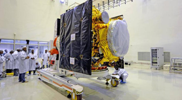
- IRNSS 1C is scheduled to take off on October 16 in the time slot of 1:32 AM to 1:47 AM (IST).
- IRNSS 1C is the third satellite in the series of 7 satellites that are scheduled to be launched. IRNSS 1A and IRNSS 1B were launched from Sriharikota on July and April this year respectively.
- ISRO needs to launch at least four of the seven satellites to start operations of IRNSS.
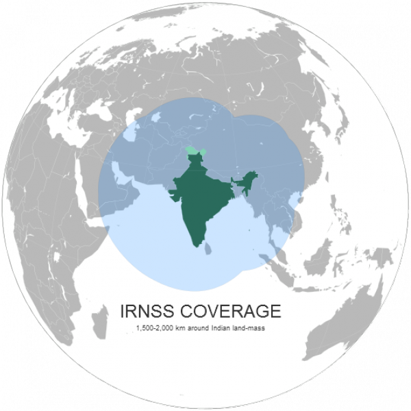
- IRNSS will provide accurate position information to the users within India as well as region extending upto the range of 1500 Km from its boundary.
This is a historical step in India’s navigation system. If it becomes a success, India will not only benefit in their military procedures but on a macro level, we’ll be judged as a South Asia’s superpower.
If IRNSS will be in our mobiles instead of GPS; I wonder whether there would be the option of getting details in the regional language as well. Time to brush up on our Hindi I guess?
Recommended: NASA’s Curiosity Rover Welcomes ISRO’s Mars Orbiter on Twitter


 Mohit Marwah